Via Francigena in Tuscany: stages, map, itinerary and things to see
Published: Updated:
The Via Francigena in Tuscany crosses the Apennines, Lunigiana, Lucca, Val d’Elsa, Siena and Val d’Orcia. The current regional itinerary covers about 394 km in 16 stages. You can walk it end to end, follow its dedicated cycling route, or build a road trip around its towns. This guide clearly separates the official trail from sightseeing itineraries by car.
For bedrooms, bed setup or arrival, message us on WhatsApp or call us directly at +39 327 003 4324.
Via Francigena in Tuscany at a glance
394 kmofficial regional itinerary
16 stagesCisa Pass to Acquapendente
16–18 daysrealistic walking schedule
May–Juneor September–October
What it is
A European cultural route shaped by medieval pilgrimages to Rome
Where it goes
Lunigiana, Lucca, Val d’Elsa, Siena, Crete Senesi and Val d’Orcia
Difficulty
Easy to very demanding; stage length, heat, water and elevation matter
On foot
Yes, on the waymarked walking route
By bicycle
Yes, on the official cycling route, which sometimes differs from the footpath
By car
You can visit the stage towns on public roads, not drive the trail
What is the Via Francigena?
The Via Francigena is not one Roman road preserved unchanged. It is a network used by pilgrims, merchants and travellers coming from the lands of the Franks and heading for Rome. In 990, Archbishop Sigeric of Canterbury recorded the stopping places on his return from Rome; his list helped reconstruct the historic route.
The Council of Europe certified it as a Cultural Route in 1994. Today it supports spiritual, cultural and outdoor journeys through several European countries.
Where does the Via Francigena start and end?
The best-known historic axis connects Canterbury and Rome through England, France, Switzerland and Italy. The cultural route continues into southern Italy towards Santa Maria di Leuca. In Tuscany it enters at Passo della Cisa; after Radicofani it descends to Ponte a Rigo, crosses into Lazio and reaches Acquapendente.
The Via Francigena route through Tuscany
The landscapes change repeatedly: wooded Apennines and Lunigiana, Apuan foothills, Pietrasanta and Lucca, Val d’Elsa hill towns, Siena, the Crete Senesi and Val d’Orcia. Visit Tuscany currently lists 394 km and 16 stages. Older sources may quote 380 or 400 km and 15 stages because they use different versions or stage boundaries.
Use the official interactive map and download the route for offline navigation before each stage. A decorative map is not safe enough for planning: the walking and cycling lines do not always coincide, and alerts may temporarily change the route.
Distance, duration and grade are from the official Visit Tuscany itinerary, checked 4 August 2026. Times exclude breaks. Stage 16 crosses into Lazio and ends in Acquapendente.
Best Via Francigena stages in Tuscany
San Miniato–Gambassi: open Val d’Elsa ridges; beautiful but exposed.
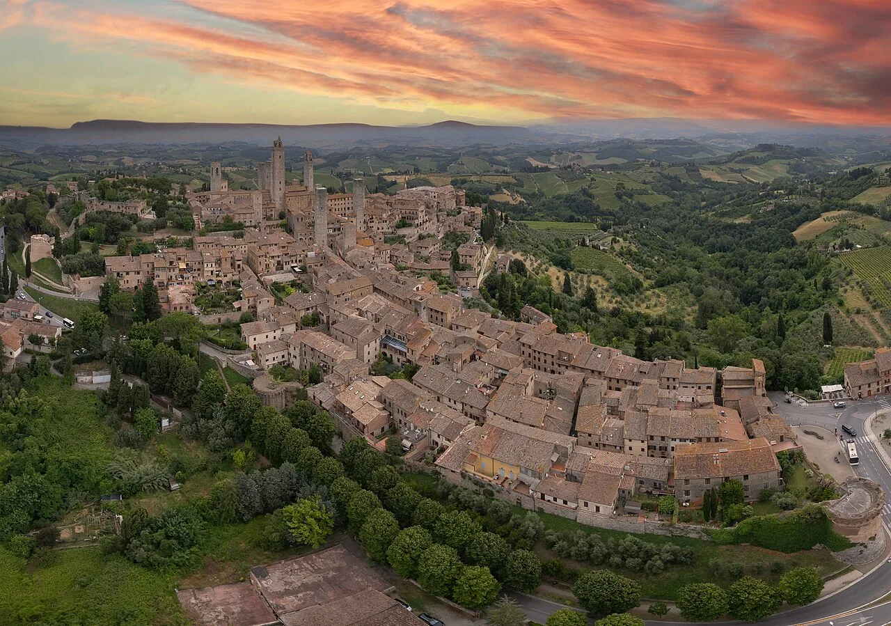
Gambassi–San Gimignano: short, approachable and visually rewarding.
San Gimignano–Monteriggioni: exceptionally varied, but 31 km long.
Monteriggioni–Siena: a historic arrival through Porta Camollia.
Ponte d’Arbia–San Quirico: Buonconvento and Val d’Orcia.
San Quirico–Radicofani: the grandest scenery and one of the hardest days.
San Miniato and Gambassi Terme
San Miniato works well as a rail-accessible starting point. Its 23.7 km stage to Gambassi crosses exposed rural ridges past Coiano and the parish church at Chianni. Carry enough water and do not rely on frequent cafés.
Via Francigena and San Gimignano
Gambassi to San Gimignano is 13.3 km and about three hours on the official schedule, passing Pancole and Cellole before the final climb towards the towers. It is an excellent first stage if your return transport is arranged. The next day to Monteriggioni is a serious 31 km walk taking about 7 hours 30.
The 20.6 km stage from Monteriggioni reaches Siena through Porta Camollia. Santa Maria della Scala, once central to pilgrim care, Piazza del Campo and the Cathedral deserve extra time. An overnight stay is more realistic than rushing on immediately.
After Ponte d’Arbia the route passes Buonconvento and Torrenieri to San Quirico d’Orcia. The next stage visits Vignoni and Bagno Vignoni before long, exposed terrain towards Radicofani. Visit Tuscany also describes an official variant through Abbadia San Salvatore; download its current track before choosing it.
Split stages over 28–30 km unless you already have endurance experience.
Use broken-in footwear and technical socks.
Carry roughly 1.5–2 litres of water, more on exposed stages.
Keep the route and alerts offline and carry a power bank.
Start early in summer and never force a swollen ford after heavy rain.
The official association describes average stages of 22–23 km and suggests a minimal 35–45 litre backpack, generally kept around 7–8 kg and adjusted to the walker.
Cycling the Via Francigena in Tuscany
Use the official cycling route; the footpath includes sections that are too steep, narrow or technical. A gravel bike with low gears is versatile. E-bikes require a realistic charging plan.
Check surface, ascent and current criticalities.
Carry puncture repair, pump, multitool, lights and a lock.
Book secure bicycle storage.
On Tuscan Regional trains, check the bicycle pictogram and current fare; spaces are limited.
A road trip visits the Via Francigena towns but never follows the walking track. Use public roads and park outside ZTL zones.
One day
San Miniato → Gambassi Terme → San Gimignano, with most of the day reserved for San Gimignano.
Two days
Day 1: San Miniato, Gambassi and San Gimignano. Day 2: Monteriggioni and Siena.
Three days
Add Buonconvento, San Quirico d’Orcia, Bagno Vignoni and Radicofani, ideally with a night in Val d’Orcia.
How many days do you need?
Entire Tuscan route on foot
16 walking days; 17–18 with rest and contingency
Lucca to Siena
6 official stages
San Miniato to Siena
5 days
One stage
1 day plus transfer logistics
Weekend
Two shorter stages or 2–3 towns by car
Road trip
2–3 days for Val d’Elsa, Siena and Val d’Orcia
Best time to walk the Via Francigena
Season
Advantages
Drawbacks
Spring
Mild weather, green countryside
Rain, mud and swollen streams
Summer
Long daylight, open services
Heat, limited shade, more water
Autumn
Harvest colours, pleasant temperatures
Shorter days and rain
Winter
Quiet trail
Possible Cisa snow and limited services
The official association generally recommends May–June and September–October.
Where to stay on the Via Francigena
Options include pilgrim hostels, religious accommodation, B&Bs, agriturismi, hotels and holiday rentals. Pilgrim accommodation may require a credential, reservation or donation and does not always provide private rooms. Confirm check-in, dinner, early breakfast, laundry and bike storage.
The credential is the official pilgrim passport for walkers and cyclists. Collect stamps at tourist offices, parishes, accommodation and participating businesses. The European Association gives a recommended contribution of €8; order online or use an official distribution point.
To receive the religious Testimonium in Rome, the credential must show at least the final 100 km walked or 200 km cycled. Recheck collection points, requirements and opening times before travel.
These are planning ranges, not official prices. Season, location, supplements and availability may change them substantially.
Food and wine along the route
Look for testaroli and chestnut dishes in Lunigiana; soups and farro around Lucca; white truffle in San Miniato in season; pici, pecorino and Tuscan soups near Siena and Val d’Orcia. Buy food before isolated stages.
Wine areas include Vernaccia di San Gimignano DOCG, Chianti, Orcia DOC and nearby Brunello di Montalcino. Plan tastings for rest days or road trips with a non-drinking driver.
Choose a short section near a town with shade, water and an exit plan; long official stages are unsuitable for untrained children.
Dogs
Plan water, heat protection and pet-friendly accommodation. Use a lead near roads, livestock, wildlife and farms; guardian dogs may be present.
Accessibility
The full trail is not step-free: dirt tracks, gradients, rough surfaces and fords create barriers. Visit Tuscany provides an accessibility sheet for Gambassi–San Gimignano. A road itinerary between stage towns is often more practical for reduced mobility.
Private luggage companies normally collect in the morning and deliver to the next booked property. Confirm coverage, weight, insurance and excluded places. Keep documents, medication, waterproofs and valuables with you.
Coastal towns, Lucca, Altopascio, San Miniato and Siena have rail access or nearby stations. Gambassi, San Gimignano, Monteriggioni, San Quirico and Radicofani often require buses and connections. Check Sunday timetables and allow a generous buffer.
Credential, ID, health/insurance documents and some cash.
Phone with offline track, cable and power bank.
Water, snacks and lunch for remote stages.
Broken-in shoes, technical socks and blister kit.
Layered clothing, sun hat, sunscreen and waterproof.
Personal medication and compact first-aid kit.
Headtorch, whistle and pack cover.
Mistakes to avoid
Using an old track without checking alerts.
Confusing walking, cycling and driving routes.
Making a 30 km stage your first loaded hike.
Starting late in summer.
Assuming every fountain or café is open.
Wearing new footwear.
Booking the last bus at your theoretical finish time.
Ignoring storms, mud and stream conditions.
Wine tasting before walking or driving.
Putting medication in transferred luggage.
Driving into ZTL zones.
Assuming a credential guarantees a bed.
Most photogenic places
Apennine descent towards Pontremoli.
Apuan Alps and coast near Pietrasanta.
Lucca walls.
Ridges between San Miniato and Gambassi.
Approach to San Gimignano’s towers.
Monteriggioni walls.
Porta Camollia arrival in Siena.
Crete Senesi and Grancia di Cuna.
Bagno Vignoni and Val d’Orcia.
Radicofani fortress.
Stay on public paths and safe viewpoints; never enter private fields for a photograph.
Via Francigena and Perla Toscana
Perla Toscana is not directly on the Via Francigena. It is a holiday home in Figline e Incisa Valdarno and can serve as a base for road trips to selected stage towns, not as an end-of-stage hostel for a continuous walk.
San Miniato
about 70–75 km · about 1 hour
San Gimignano
about 62 km · about 1 hr 10
Monteriggioni
about 72 km · about 1 hr 10
Siena
about 75 km · about 1 hr 10
San Quirico d’Orcia
about 105 km · about 1 hr 35
Radicofani
about 135 km · about 1 hr 55
These are rounded driving estimates and depend on traffic, roadworks and parking. A one-way walk still requires a transfer or car-recovery plan.
There is no single correct Via Francigena trip. Sixteen continuous stages, a weekend walk, a cycling section and a three-day road trip reveal different parts of the route. Match the plan to fitness, season and transport rather than treating the towns as a checklist.
Perla Toscana can be a transparent base for driving to San Gimignano, Monteriggioni, Siena and central Tuscany; continuous walkers should stay in the actual stage towns.
Recommended local guide
San Gimignano: towers, parking and itinerary
Plan a day in the medieval town with distances, current parking information and a realistic walking route.
The best-known historic route starts in Canterbury and heads to Rome. In Tuscany it enters at Passo della Cisa.
Where does the Via Francigena end?
Rome is the main historic destination. The cultural route continues through southern Italy towards Santa Maria di Leuca.
How long is the Via Francigena?
The total depends on the route version and endpoints. The official Visit Tuscany section lists 394 km for the 16 Tuscan stages.
How many kilometres are in Tuscany?
Visit Tuscany currently gives 394 km. Other sources round the figure to 380 or 400 km because they use different versions or boundaries.
How many days are needed in Tuscany?
Allow 16 walking days, or 17–18 with rest and contingency. San Miniato to Siena takes about five stages.
What is the best Via Francigena stage in Tuscany?
Gambassi to San Gimignano is an approachable scenic choice. San Quirico to Radicofani has exceptional scenery but is very demanding.
Can you cycle the Via Francigena?
Yes, using the official cycling route. Do not automatically follow the walking track.
Can you tour the Via Francigena by car?
You can visit the route towns by road, but you cannot drive the walking trail. Use public roads and park outside ZTL zones.
Is the Via Francigena difficult?
It is not mountaineering, but some stages exceed 30 km and include elevation, dirt surfaces, heat and limited water.
Is it suitable for children?
Selected short sections can work, but long official stages are generally unsuitable for untrained children.
What is the best time to go?
May–June and September–October usually provide the best balance of temperatures and services.
Do you need a pilgrim credential?
It is not required to walk, but records stamps, may unlock dedicated services and is needed for the Testimonium.
Where do pilgrims sleep?
Pilgrim hostels, religious accommodation, B&Bs, agriturismi, hotels and holiday rentals are available, with varying rules and availability.
How much does it cost?
A basic daily budget may start around €45–70, while private rooms, high season, transfers and luggage services can exceed €100–150.
Does the Via Francigena pass through San Gimignano?
Yes. One stage arrives from Gambassi Terme and the next continues to Monteriggioni.
Does it pass through Siena?
Yes. The route enters through Porta Camollia and crosses the historic centre.
Does it cross Val d’Orcia?
Yes. It passes San Quirico d’Orcia, Vignoni, Bagno Vignoni and continues to Radicofani.
Is Perla Toscana on the Via Francigena?
No. It is in Figline e Incisa Valdarno and works as a driving base for selected day trips, not as accommodation directly on the trail.
Availability
Check availability for Perla Toscana
Check available dates and send us a direct request simply and securely. For questions about bedrooms, bed setup, arrival or amenities, message us on WhatsApp or call us.